Stroll 4 – Trees and hedgerows
Discovering secret clues to ancient boundaries
Distance: 6½ miles or 10km Time: (approx) 3hours
- For a handy, printable PDF version, click here -
----------------------------------------
This longer ‘ramble’ uses ancient footpaths, country tracks and a short section of quiet lane. There are 27 stiles and 9 gates. Superb views.
Start from The Fighting Cocks, Stottesdon 1
1 Take the Burwarton road for 250m to bench opposite The Surgery; turn right to bridleway, 150m through farmyard; turn left at waymark by barn.
2 Down to, through gate (bottom left of field) note impressive ‘hedgerow oaks’ typical of this landscape; keeping hedgerow left, go to top of field, through gate; ahead (to right of cottage) to cross stile; turn right on track (100m) to next stile (left).
3 Downhill toward Pickthorn Farm, crossing two stiles/bridge at ditch. Wooded mound (right) was once a Motte & Bailey castle – then until 1760, site of Pickthorn Hall. Continue up to top right of field.
4 Through gate; turn left on lane -an ‘old road’ confirmed by thick hedgerows (native English mix of hawthorn, elder, hazel, field maple, holly, ash, dogwood)- for 300m; turn right at gateway (views across to Brown Clee) onto waymarked footpath down to old barn –two veteran oaks (left) are ‘survivors’ of ancient hedge boundary.
5 Through gate, around barn; then diagonally across field to next gate at edge of ‘Wallfurlong Rough’ – Hawthorn blossom and Red Campion flower in Spring. Enter wood; follow fence line (right) then bear left; cross footbridge; over stile; head up to top left corner of field.
6 Cross double stile (views to Titterstone Clee); across next field (keep oak trees left); over stiles either side of small spinney (‘Rowleys’); bear half-left, down along far edge of wood, to cross next stile; follow field edge (left) down, to cross two stiles on opposite sides of farm track.
7 Head half-right, diagonally down field, to gate by stone bridge over ‘Winterburn Brook’ (its name hints that this brook was once ‘dry’ in summer; unlike nearby streams, this one never powered a watermill.)
8 Cross bridge; bear left across the field towards ‘Walkerslow Rough’; follow edge of wood up slope, through three gates, to cross stile; turn left over next stile.
9 Follow hedge down to cross another stile/footbridge, then head diagonally across field to cross stile at road; turn left over the ‘Rea Brook’ bridge (‘Rea’ – OE ‘ea’ pronounced ‘ree’ - meaning ‘stream’.)
10 In 50m, turn left into field; over stile ahead, then up hill (field oaks, left) to cross stile into ‘The Thorns’ (is this spinney aptly named?); straight through to cross stile back into field; head half-left to field boundary; follow hedge to join track by cottage.
11 Turn left; follow track (650m) passing ‘Squintum Coppice’ (ancient, seminatural woodland, right) then down the slope towards Rea Brook.
12 Turn right over stile just before brook; head diagonally right towards far corner of coppice. Cross ‘Cleobury Brook’ by old stone bridge (marks boundary with Aston Botterell Parish) over field to cross the stile opposite; turn half-right to footpath junction just below ‘The Ford’ farm.
13 Follow path back on itself to cross Rea Brook by another stone bridge; head uphill to top right of field; cross double stile (ancient hedge marks parish boundary here); follow hedge line (left) down to cross the alder-lined stream near Wallfurlong Rough; follow wood edge up and round to stile. Path ahead cuts through corner of wood (Scots pines); over bridge to cross stile on far side. Bear left, cross next stile; bear right, uphill, to cross complex-stile in hedge on bank; ahead, slightly left, over field to cross stile; then cross track ahead.
14 Take marked path to cross stile far side of small spinney; follow hedge line (left) for 1.2km, down through two
fields to footbridge over stream, then up and down through two more fields to cross another footbridge.15 Head uphill (parallel with hedge, right) to cross stile (by gate in top right of field) just below The Surgery passed earlier. Follow road back into village.
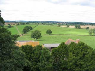
This walk is characterised by isolated mature oak trees, many of which indicate ancient hedgerows. When three or more oaks occur in a straight line, this is a good indication that they were part of old field boundaries -with hedgerows now removed, to allow for mechanised farming methods.
It is the hedgerows which give Shropshire countryside a “patchwork” appearance. They mark old field-patterns; act as wildlife ‘corridors’ through the countryside; provide food (nuts, nectar and berries) for people, birds, mammals and insects; and shelter stock in bad weather.
The numerous streams that are frequently crossed are characterised by the lines of streamside alders which would once have been regularly coppiced (cut back) for their timber. Alder was valuable in the charcoal industry and was famously used in the manufacture of gunpowder. However, today with the trees no longer being coppiced, the alders have reverted to the long spindly lines of trees we see today.

